Date : 4th May 2013
Route : From Howtown along the Roman Road to High Raise and back via Martindale
Wainwrights : Arthur's Pike, Bonscale Pike, Loadpot Hill, Wether Hill, High Raise, Kidsty Pike, Rampsgill Head, The Knott, Brock Crags, Rest Dodd, The Nab, Hallin Fell
Distance : 30 km (18.6 miles)
Height Gained : 1436 m (4711 feet)
Time taken : 11 Hours
 |
| The Route - Clockwise from Howtown |
I had planned a long walk today to take advantage of the lengthening days but with a number of opportunities to cut it short if stamina was found wanting. An early start had me in full rain gear at 6:30 after parking near the zig zags in the road by Howtown. It was drizzling steadily but the weather forecast was reassuringly optimistic that things would brighten up later.
 |
| A calm Ullswater on the drive in |
 |
| Hallin Fell in the rain from the Bonscale path |
 |
| Arthur's Pike |
There was no easy way to climb the steep west side of Arthur's Pike so it was a case of following the path northwest past Bonscale and Arthur's Pikes towards Barton Park and then cutting back so as to gain the ridge from the north side. Along the path the rain suddenly stopped and the sun came out.
 |
| The sun comes out and illuminates Ullswater and Hallin Fell on the left |
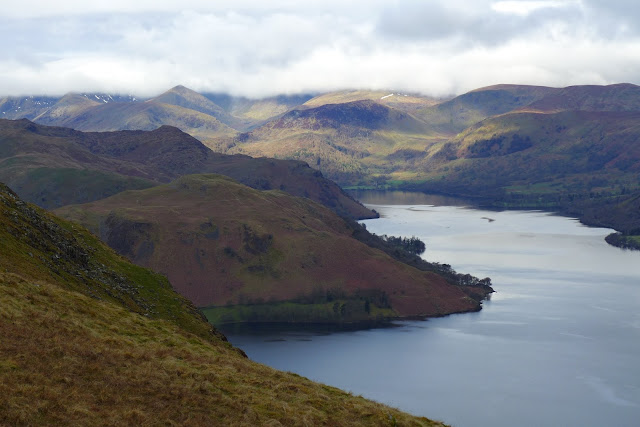 |
| The view over Ullswater from the approach to Arthur's Pike. Catstye Cam peeping though the cloud on the horizon |
 |
| Arthur's Pike summit |
From Arthur's Pike a path continues southeast towards Bonscale Pike and the stone pillars of Bonscale 'towers', the lower of which provides a great viewpoint down to Ullswater.
 |
| Bonscale Towers, old and new |
 |
| Bonscale Tower overlooking Ulswater and Hallin Fell |
The path then continues south to join with the old Roman Road but a slight deviation eastwards is then required to reach Loadpot Hill.
 |
| The Boredale Valley from the walk to Loadpot Hill |
 |
| Loadpot Hill summit cairn |
Its then an easy path for a mile along the Roman Road to Wether Hill, the summit of which is a small pile of stones to indicate the apparent high point of an otherwise expansive featureless grassy plateau.
 |
| Finally some rocks on the Roman Road to Wether Hill. High Raise summit just in mist |
 |
| Wether Hill summit panorama west |
The Roman Road continues south towards High Raise. This must be a fell runners paradise but by this time I was getting fed up of grass underfoot and was looking forwards to the promise of more rocky terrain on the fells to follow.
 |
| Place Fell over Beda Fell from the path to High Raise |
 |
| The view onwards to High Raise |
 |
| High Raise summit looking south |
 |
| High Raise summit view north back along the path to Wether Hill and beyond |
 |
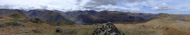
| High Raise panorama east |
 |
| High Raise panorama west |
 |
| Fairfield from High Raise |
 |
| The Helvellyn range over Rest Dodd |
 |
| Rest Dodd and The Nab from High Raise |
 |
| Looking south from High Raise; Kidsty Pike left, Rampsgill Head right, High Street in the middle |
Kidsty Pike is a must visit from High Raise as it offers the first good view of Haweswater and is a great view point for the Riggindale valley.
 |
| Kidsty Pike summit |
 |
| The Riggindale valley and Haweswater from Kidsty Pike |
 |
| High Street from Kidsty Pike |
 |
| The superb southern panorama from Kidsty Pike |
 |
| Kidsty Pike view west to Rampsgill Head |
The path westwards follows a gentle depression before rising up a little to a few cairns indicating the summit of Rampsgill Head.
 |
| Rampsgill Head summit panorama |
 |
| Rampsgill Head summit view west |
 |
| Striding Edge, Helvellyn and Swirral Edge from Rampsgill Head |
 |
| The Knott (left) and Rest Dodd (right) |
The next objective was The Knott which is an easy path down towards the stone wall seen in the picture which then follows it to the summit.
 |
| The Knott summit view towards High Street |
 |
| The Knott summit panorama east |
 |
| The Knott summit panorama west |
 |
| Brock Crags (left) and Rest Dodd (right) - from The Knott |
At this point I was in 2 minds whether to take in Brock Crags which from this view seemed a long way off the obvious route to Rest Dodd. After considering the great weather and with no compelling reason to rush back, I set off westwards to bypass Rest Dodd. It was worth the detour. The views from Brock Crags were some of the best from the day.
 |
| Hayeswater from the descent of The Knott |
 |
| Angle Tarn from near Brock Crags - wild campers just visible on the little 'peninsula' |
 |
| Brock Crags view over Brothers Water |
 |
| Brock Crags view back over Gray Crag to the High Street range |
 |
| Brock Crags summit panorama west |
 |
| The view back to Rest Dodd and The Knott from Brock Crags |
It felt like a long trudge back towards Rest Dodd and the steep climb to this 10th summit of the day was punishing on the old legs.
 |
| Rest Dodd summit view west back to Brock Crags; Brother Water left, Angle Tarn right |
 |
| From Rest Dodd, the way back to Ullswater over The Nab |
It was a steep descent down from Rest Dodd and then awkward terrain over peat hags before reaching The Nab.
 |
| The Nab summit panorama east and the route already trodden |
 |
| The Nab summit panorama west |
 |
| Looking down a very steep descent into Martindale from the Nab |
 |
| The 'north face' of The Nab |
The steep route down directly north from The Nab is one of steepest I have encountered in the Lakes. Although the photo above perhaps doesn't illustrate the inclination well, I can assure you, it was very steep! At this point the legs were tired and my mind was set on getting back to the car and calling it a day but by the time I reached the foot of Hallin Fell I decided there was just enough left in the tank to get me to the summit.
 |
| Place Fell from the foot of Hallin Fell, The Nab visible far left |
 |
| Hallin Fell summit cairn looking north |
 |
| Hallin Fell summit panorama west |
 |
| Hallin Fell summit view southwest |
 |
| Hallin Fell panorama east |
 |
| Nearly back at the car with Bonscale Pike and Arthur's Pike beyond |
So that's 93 Wainwrights so far and still a long way to go. Looking forwards to the remaining 121.


