Showing posts with label mountain. Show all posts

Monday, January 11, 2021

Bowfell - Mountain Profile


Bowfell
Height: 2959 feet (902 meters)
Area: Southern Fells

Bowfell is the 6th highest mountain the Lake District. It's pyramid shaped profile stands at the head of the Great Langdale, Eskdale and Langstrath valleys.

It forms part of a continuous horseshoe ridge of high rocky ground from Crinkle Crags at the south eastern end to Slight Side at the south western end, with Great End and the Scafell Massif occupying its northern apex.

Angle Tarn sits in a glacial corrie under the steep eastern crags of Bowfell. A cluster of much smaller tarns called '3 tarns' (but varying between 1 and 5 bodies of water depending on weather) nestle in the col between Bowfell and Crinkle Crags.  

Bowfell is most commonly climbed from Stool End Farm in the Great Langdale valley via the 'Band', or as part of a ridge walk from Crinkle Crags. It can also be climbed from the Eskdale or Mosedale valleys from where its steep gully scarred southern aspect (Bowfell Links) can be best appreciated.

Bowfell Walks :-

: from Oxendale via Crinkle Crags
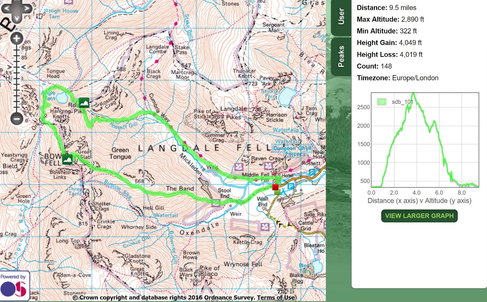
from The Band & Climbers Traverse (and then on to Scafell Pike)
from the Band & Climbers Traverse in Winter

Bowfell Summit View Panorama


Crinkle Crags and Bowfell over the Oxendale valley

Bowfell Links from Shelter Crags, at the northern end of Crinkle Crags
  
Bowfell and Esk Pike from Esk Hause

Bowfell over Angle Tarn

Great Slab and the Boulderfield from Rossett Pike

A Classic Lakeland View - The Great Slab on Bowfell

Bowfell Summit, looking south over Crinkle Crags

Bowfell summit panorama west - towards the Scafells

Bowfell summit panorama east - towards Langdale

Saturday, September 29, 2018

Scafell Pike via the Corridor Route from Seathwaite


Date: 28th Sept 2018
Start/Finish: Seathwaite
Route: Up to Styhead Tarn and then on to Scafell Pike via corridor route. Return over Great End and Grains Gill.
Wainwrights: Scafell Pike, Great End.
Time Taken: 7 Hours


Below is a 3D fly-through of the route 


I've climbed Scafell Pike many times; from Wast Water, Eskdale and Langdale but never from Seathwaite via the corridor route. So this was about hiking a new route up a familiar mountain. I drove up the night before in the camper van and parked in Seathwaite. This way I could get an early start after a good nights sleep. I chose the classic circular route up Styhead Gill to Sty Head and then along the corridor route to Scafell Pike before heading back via Esk Hause and Grains Gill. I made a few small deviations onto Broad Crag, Ill Crag and Great End for the views.


Accommodation in Seathwaite


Seathwaite Fell over Stockley Bridge


Looking back along Styhead Gill


An unnecessarily large cairn near Sty Head


Styhead Tarn


Great End 


The usual wild campers around Styhead Tarn unsurprisingly forgetting the bit about 'always pack up before the day hikers arrive' 


A lone hiker near the start of the corridor route


The corridor route heading towards Piers Gill


Piers Gill

Heading towards Lingmell Col


The top of Piers Gill

Lingmell and Great Gable from the path up to Scafell Pike 


Scafell Pike summit - under cloud
I had lunch in one of the many wind breaks near the summit but unfortunately the cloud didn't look like it was going to lift any time soon, so I headed off down the badly eroded path to the col at the top of little narrowcove before heading up to Broad Crag and then across to Ill Crag.


Looking down little narrowcove gulley


Broad Crag summit


Ill Crag


Looking down the Esk valley from Ill Crag


Bowfell from Ill Crag


Great End


Views down to Borrowdale from Great End


The top of Central Gulley on Great End


Great End summit views over to Glaramara 


Ill Crag, Broad Crag and Scafell Pike now cloud free


Views over Esk Hause towards Esk Pike and Bowfell


Esk Pike from Esk Hause


Views of the route back down to Seathwaite, the Borrowdale valley and Derwent Water beyond


The Langdale Pikes


Great End and Great Gable


The bottom of Central Gulley


Grains Gill and the path back to Seathwaite


Now this is undoubtedly a lovely walk in a stunning landscape but the day was somewhat tarnished by the strange behaviour of some folk along the way. I know it was Scafell Pike on a Saturday with a half decent forecast and so I expected a crowd but there were literally hundreds of people of the mountain, including someone shouting obscenities from the summit at the top of their voice (a lost bet maybe?) when so may folk were around including children. Also, there was a group of 30 ish strewn along a mile section of Grains Gill whose chief method of communication was to repeatedly yodel at each other. Now I'm all for a good yodel in the Swiss alps when needs must but this was ridiculous and just annoying to everyone within earshot.

It also seemed that there was a festival of tissue paper on the mountain today. Every 50 yards or so the path was decorated with the stuff. And then, to add to my disillusionment, I was asked 5 times by different groups where Scafell Pike was. None had a GPS, map or compass. I also encountered folk in jeans & brogues and a girl in a leather bikers jacket complete with tassels, who unsurprisingly looked thoroughly miserable on the Scafell ascent in clag, 30mph gusts and 2 degrees above zero. I really feel for the poor Mountain Rescue Teams who must despair at the sheer idiocy of some people. Ah well. Rant over. It's a lovely area. Just go midweek and early morning, or leave it until winter.

Tuesday, December 13, 2016

Taking the Boy up Bowfell (AKA the Eiger) via climbers traverse in winter


Video of the walk


Date: 3rd December 2016
Start/Finish: Old Dungeon Ghyll
Summits: Bowfell (2959 feet), Rossett Pike (2136 feet) [and the Eiger! 13,020 feet]
Distance: 9 miles
Elevation: 4076 feet
Time Taken: 6 hours


The Route : Clockwise from Old Dungeon Ghyll (far right)

It had been ages since I was last in the fells. Five months in fact. The main reasons were 1) getting a new job 2) having a child who needs driving to football-lots 3) bad weather whenever I planned a trip. Anyway, it was time make amends. My 9 year old was keen to get out for a hiking adventure and I had promised to take him up Bowfell. Stories of steep crags, exposed routes and stunning views had whetted his appetite and there was also the chance of some snow high up which added to the excitement. 


We parked up near the Old Dungeon Ghyll and headed off through Stool End Farm and up the Band. Patches of snow were visible higher up but the summit of Bowfell remained elusively under cloud. As he had managed Blencathra with ease in the summer I thought that the climbers traverse / great slab route would be good challenge for him, especially if there was a bit of snow around. However, as we didn't have axe's & spikes I was prepared to turn back or change routes if needed 
(I had checked the various web cams, weather forecasts and blogs and was satisfied that any snow/ice would be patchy and avoidable).


Stool End Farm


Oxendale Beck 


A friendly local


Pike O'Stickle


Looking back along the Great Langdale Valley


First patch of snow high up on the Band

We headed up the Band until leaving the main path to access climbers traverse (a detailed description of how to find the route is described here). At this point we encountered the first few patches of snow which the boy promptly jumped in, got his gloves soaking wet and his hands cold. No problem though. I has prepared for such eventualities and had a rucksack full of spare warm stuff. So on went the waterproof mitts and the conversation turned to famous mountaineers and epic alpine adventures. Before long his imagination was fired and we were embarking on the first ascent of the Eiger. He had great fun climbing up a steepish patch of snow using 2 poles and plenty of grit and determination. He felt like a real mountaineer and I was happy that the slope gradually levelled out at the bottom where there were no rocks to slide into if he slipped.  


Struggling up the the Eigers fiercesome north face !  

Up to his thighs on the 'Rote Fluh'


Kicking steps on the 'White Spider'

Having successfully conquered the Eiger we returned to Bowfell and made our way towards the climbers traverse. It was great to take my son along this narrow route which winds its way amongst some of Lakelands most spectacular rock scenery. The presence of a few snow patches added to the adventure. 


Climbers Traverse .....


..... or rather the Hinterstoisser Traverse!


Looking towards Bowfell Buttress


The water spout under Cambridge Crag

A hyperlapse video of climbers traverse


We stopped for a well earned rest and a bite to eat by the water spout at the bottom of Cambridge Crag before heading off for the final push up the steep boulder field by the famous Great Slab.


Views over Great Slab towards the Langdale Pikes


Scrambling up the boulder field


A misty Great Slab

From the top of Great Slab its just a short amble to the shattered summit of Bowfell. Unfortunately there were no views today so we didn't linger. Instead we headed quickly off towards Esk Pike but then got distracted by more large snow fields which just had to be walked over, slid down and jumped in.


Getting back below the cloud and about to 'bum slide' down this inviting slope


Views over to Esk Pike

How Exciting!?

By the time we had finished playing around it was clear that we wouldn't have enough daylight left to climb over Esk Pike and come back via Esk Hause as originally planned. Instead we took a short cut down to Angle Tarn at Ore Gap where even more large snow fields distracted us into further fun and frolics. By the time we bagged Rossett Pike and got down the Rossett Gill path it was going dark. Head torches were deployed for that last mile along the Cumbria Way back to the car. This made for a last bit of excitement before the end of a perfect lad & dad adventure.


Snowball action shot


The arty black and white shot of Angle Tarn


Bowfell summit now out of cloud ..... typical!


Trying to make a snow angel


Icing a limb threatening wound on Rossett Pike summit


Looking down Rossett Gill and back along the Great Langdale Valley

Next on the adventure radar .... The Matterhorn!